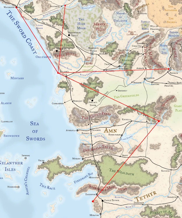
The Lost Princess Road was not a true road but a series of linked portals that connected sites along the Sword Coast, Waterdeep, Tethyr, Amn, Cormyr, and the Savage Frontier. The intrepid explorer and author Volothamp Geddarm chanced upon it sometime around the Year of the Tankard, 1370 DR, probed its workings, and published his findings (after Elminster screened the manuscript).[1][2][3]
Map showing the locations and connectivity of the portals making up Lost Princess Road. Click to enlarge.
Description
The main hub of Lost Princess Road was Skarn Rock just off the coast near Baldur's Gate. From this point in the network, one could reach the Bridge of Fallen Men at the western edge of Cormyr, a grove of trees beside the Unicorn Run east of Secomber, the backyard of Silavene's festhall on Mount Waterdeep, and an abandoned quarry in the remote barony of Hawkhill in northeastern Amn. From the Hawkhill quarry there was one other branch of the network that connected to a seaside hill just south of the Convent of St. Rhynda in the Purple Hills of Tethyr.[1][2][3]
The portal in the Purple Hills was likely the cause of the mysterious disappearance of Princess Darseera (within two or three decades of, but probably in the Year of the Lost Princess, −261 DR) for whom a ballad was written to tell her tale. The ballad was titled "Lost Princess Road" and is how the network of portals got its name.[1]
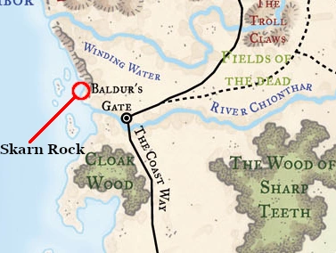
Skarn Rock
Map showing approximate location of Skarn Rock.
This barren strip of stone pounded by the waves in the Sea of Swords was only about 60 feet (18 meters) away from the cliffs of the Sword Coast a short distance north of the mouth of the River Chionthar.[3] On the landward side of Skarn Rock were four shallow pits, barely a dozen feet (3.7 meters) above the high tide mark, in two pairs. Each pit was perhaps three feet (90 centimeters) across, two feet (60 centimeters) deep, and long enough to hold a human body. Both the north pair and the south pair were so close together that only a thin blade of stone separated them.[2]
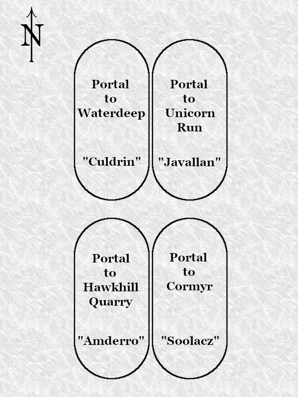
Orientation of the portals on Skarn Rock, with activation words.
The four portals did not operate without the proper activation conditions. Volo discovered that standing in one pit and shedding a drop of his blood into its twin was one way to activate the magic. Elminster, in an effort to reduce unnecessary bloodletting, revealed that each portal had an activation word, and that placing one foot or even extending a hand into a pit was enough to be teleported to the desired destination. The words of power were "Soolacz" for the Cormyrean destination (southeast pit), "Javallan" to reach the Unicorn Run (northeast pit), "Culdrin" for Mount Waterdeep (northwest pit), and "Amderro" for a jump to the Hawkhill quarry (southwest pit). It was believed that these four command words were the names of the individuals who created the Road.[2]
Arrival at Skarn Rock from one of the four spokes was in a pit seemingly chosen at random. Taking another portal required the person to step out of their arrival pit and then enter another (or the same one) before activation. Thus, an unfortunate individual that was bleeding was not likely to be immediately transported away again.[4]
The gates were protected against those foolish enough to attempt to use them without complete knowledge. Saying the wrong word for the portal being activated released from one up to six vampiric dread (disembodied skeletal arms that could fly and swim) that rose out of the pit and attacked until destroyed. They gained health from those they successfully struck and would follow a victim through a gate if he or she happened to trigger one correctly. In addition, the northern pair of pits had another trap laid on them. While standing in either pit, casting a spell or invoking a magic item caused the victim to experience reverse gravity until they were 80 feet (24 meters) in the air before normal gravity was restored.[2]
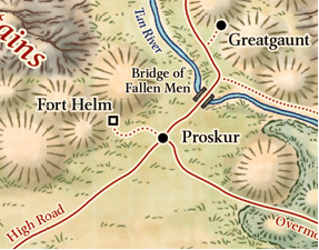
Map of the area around the Bridge of Fallen Men.
Bridge of Fallen Men

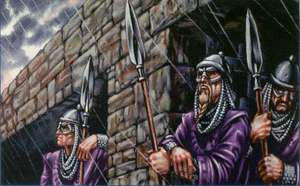
Purple Dragons taking shelter under the bridge.
The southeastern portal from Skarn Rock transported a being to the top of a large boulder on the west side of the Tun River downstream from the Bridge of Fallen Men.[2][3] The nearest town on this side of the river was Proskur.[5]
The boulder was part of the rocky slope of the river gorge and had four shallow holes chiseled in a horizontal row, roughly oriented north–south. Inserting a (living) body part, such as a hand, foot, or elbow, simultaneously into the two northern holes teleported the person back to Skarn Rock. Anything, living or otherwise, placed into either of the southern holes was immediately thrust back out with enough force to cause significant harm, not to mention the additional damage from tumbling down the rocky gorge if a being could not resist the stunning punch.[4]
Travelers of Lost Princess Road were advised to arrive in darkness and in silence to minimize the chance of being discovered. In the 1370s DR, mounted patrols from Cormyr guarded the Bridge of Fallen Men, and off-duty Purple Dragons often took shelter from the heat or the weather underneath the bridge.[4]
Unicorn Run

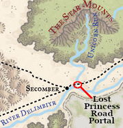
Map showing approximate location.
The northeastern portal at Skarn Rock deposited a traveler on a pile of rocks in the midst of a grove of duskwood trees that grew between two rivers. The portal was closest to the east bank of the Unicorn Run, but was not far from the north bank of the Delimbiyr River.[2][3] The Delimbiyr Route was also within walking distance of the grove.[5]
Most of the stones at the arrival point were a nondescript gray, but there were two special stones, one white and one black, that were embedded in the ground about seven feet (just over two meters) apart. Activating the gate back to Skarn Rock required a person to touch both stones at the same time. A sufficiently tall person could lay on the ground and reach both stones, but placing a foot on one and reaching to the other with a staff, sword, or even a branch from the woods was sufficient to meet the trigger conditions.[4]
Silavene's Festhall
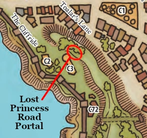
Map showing approximate location. Silavene's is labeled C3.
The north spur of Mount Waterdeep was the destination of the northwestern portal at Skarn Rock. The gate-stone was located up a narrow path that climbed the slope behind Silavene's festhall[3] to a small area screened off by mosses and spreadleaf plants. Although the trail led to the back door, visitors were wise to walk around to the front and talk to the human guards before attempting entry. The back doors of Silavene's were ensorcelled to transform into helmed horrors if any spell or weapon was used on the locks or hinges, or if the outer layer of their armor plating was breached. During good weather, Silavene's was quite busy at all hours of the day or night and the walk to the front door passed a number of private arbors and bowers where business was conducted.[4]
Activating the return trip to Skarn Rock required the traveler to touch the gate-stone while carrying either a burning flame (like a candle or a torch) or a piece of obsidian. Any flame taken through the portal was extinguished instantly, but the burning implement was not otherwise altered.[4]
Hawkhill Quarry
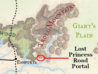
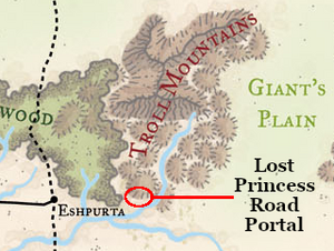
Map showing approximate location.
A quarry on the lands of the barony of Hawkhill nestled in the foothills of the Troll Mountains in eastern Amn[note 1][3][6] was the terminus for the southwestern portal of Skarn Rock. Originally this location was a cavern, but at some point in time it collapsed and exposed the stone walls and formations.[1] These attracted the local stonecutters to take what they could use, but by the 1370s DR, the quarry was abandoned and claimed by nature. However, one feature was left undisturbed by humans or nature—a double pair of pillars carved into the former cave wall and covered in arcane runes. Each pillar was twice the height of a man and less than an arm's length from the wall. Between each pair was a hole in the wall about chest-high and fist-wide (human-based dimensions again) and about four feet (120 centimeters) deep.[2]
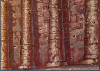
The double pair of pillars, with keyholes, at the Hawkhill quarry.
The four pillars were aligned roughly west to east. To activate either gate required standing between the pillars and inserting a metal object, such as a spear or javelin with a metal tip, into the hole or, according to Elminster, uttering a trigger word. If the keyhole was used, the object remained in the possession of the wielder and was unharmed. The east gate could also be activated by the word "Hoaloal" and connected to Skarn Rock. The west gate could be triggered by uttering "Avalarray" and connected to a barren hilltop in the Purple Hills of Tethyr by the sea.[2]
The mysterious runes that covered the pillars were a ruse to impress local yokels so they would think twice about trying to remove the decorative columns. Elminster reported that Shardrin, a wizard from Memnon, added them as a precaution sometime in the early 1300s DR. However, these portals were not without defenses. Any offensive spell cast at the pillars, or any metal object striking them or the stone base they appeared to grow out of caused chain lightning to flash out of the targeted piece on every strike.[2]
Purple Hills
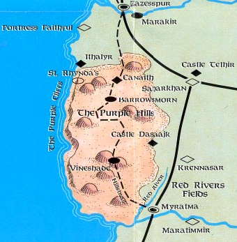
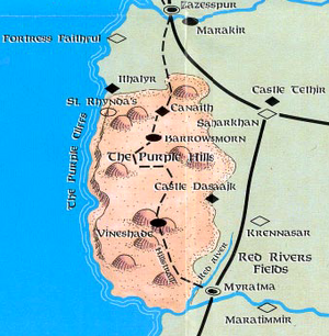
Map showing the location of St. Rhynda's

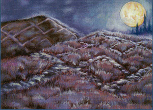
Moonlit hills south of St. Rhynda's in the Purple Hills. The outlines of sturdy walls were still visible.
Travelers that arrived from northeastern Amn found themselves atop a low, bare hill that, in the 1370s DR, had only one stone on it. This smooth square of rock was the only indication of the portal at that spot. Travelers could arrive at any time, but the trip back to Hawkhill was only possible when Selûne shed her light upon the stone—then a single step onto the square was all that was required. Examining the ground during the daylight hours revealed the straight lines of what once were walls surrounding the hill and its taller neighbor to the west. From the outlines, it appeared that a castle once stood on the western hill overlooking the Purple Cliffs and the Sea of Swords. The nearest major landmark was the Convent of St. Rhynda, a relatively easy walk northward over steep, bramble-covered hill country.[1]
Appendix
Notes
- ↑ The estimate of the location of Hawkhill was based on the description by Ed Greenwood as being north of the duchy of Scarnshields, which had good fishing (see the Sage Advice archive of Ed Greenwood's twitter feed). The Khalleshyr river is described as being known for a rare fish (Lands of Intrigue: Amn page 38) and the Valashar river is described as being too dangerous (Lands of Intrigue: Amn page 43), so Hawkhill was placed in the hills north of the Khalleshyr.
References
- ↑ 1.0 1.1 1.2 1.3 1.4 Ed Greenwood (Februry 2000). “The New Adventures of Volo: Lost Princess Road”. In Dave Gross ed. Dragon #268 (Wizards of the Coast), p. 89.
- ↑ 2.0 2.1 2.2 2.3 2.4 2.5 2.6 2.7 2.8 2.9 Ed Greenwood (Februry 2000). “The New Adventures of Volo: Lost Princess Road”. In Dave Gross ed. Dragon #268 (Wizards of the Coast), p. 90.
- ↑ 3.0 3.1 3.2 3.3 3.4 3.5 3.6 Eric L. Boyd (June 2005). City of Splendors: Waterdeep. (Wizards of the Coast), p. 16. ISBN 0-7869-3693-2.
- ↑ 4.0 4.1 4.2 4.3 4.4 4.5 Ed Greenwood (Februry 2000). “The New Adventures of Volo: Lost Princess Road”. In Dave Gross ed. Dragon #268 (Wizards of the Coast), p. 91.
- ↑ 5.0 5.1 Map included in Ed Greenwood, Sean K. Reynolds, Skip Williams, Rob Heinsoo (June 2001). Forgotten Realms Campaign Setting 3rd edition. (Wizards of the Coast). ISBN 0-7869-1836-5.
- ↑ Ed Greenwood, Eric L. Boyd (March 2006). Power of Faerûn. (Wizards of the Coast), p. 13. ISBN 0-7869-3910-9.